

Mozilla Stumbler

Deskripsi Mozilla Stumbler
Mozilla is a nonprofit project and global community building a better internet.
is an open-source wireless network scanner that collects GPS data for the
, our crowd-sourced location database. As you move around, the app "stumbles" upon new Wi-Fi networks and cell towers. The Mozilla Location Service combines these wireless network measurements to provide geolocation services for Firefox and other open source projects. For more information, visit our project page:
• https://location.services.mozilla.com
• The app stops/pauses
when you are not moving or your battery is low. (This feature works better on newer devices as they have better sensors).
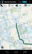
• Go to un-stumbled areas (not covered in blue) to fill in the coverage map: https://location.services.mozilla.com/map
• Improve the accuracy of the service by stumbling in the blue areas.
• Try walking, biking, or driving new routes with Mozilla Stumbler every day!
• Start with major streets and intersections, then explore smaller streets.
• Your contributions will take a day to show up on the coverage map.
• Please report bugs on GitHub: https://github.com/mozilla/MozStumbler/issues
• or the #geo IRC channel on https://wiki.mozilla.org/IRC
To conserve cellular data usage, the Stumbler's map view only shows high resolution map tiles on Wi-Fi. In the
, you can change this to always show the high resolution maps,
• Mozilla Stumbler is open-source software. The code is available on GitHub: https://github.com/mozilla/MozStumbler


